
Jenna Courtade
- Visiting Librarian for Architecture Archives and Reading Room Services
- jmc525@miami.edu
- (305) 284-3354

Gilda Santana
- Director, Architecture Research Center / Art & Art History Librarian
- gsantana@miami.edu
- (305) 284-5282
http://www.oldmapsonline.org/
Example of time-series study with Daytona Beach topo maps:
Daytona Beach 24K 1952
Daytona Beach 24K 1980
Daytona Beach 24K 1993
United States Geological Survey:
Over 100K modern and historic scanned topographic maps of the United States.
USGS Map Locator & Downloader
Yale University Beinecke Library Digital Maps: thousands of antique scanned maps.
http://beinecke.library.yale.edu/
Library of Congress:
Digital Collection with over 15,000 scanned maps.
http://www.loc.gov/maps/collections
OpenGeoportal:
Source for GIS data and scanned maps from a consortium of dozens of Universities & Organizations.
http://data.opengeoportal.org/
Sanborn Fire Insurance Maps:
Detailed scale maps mostly of United States towns & cities c. 1880-1930
Michigan State guide to Sanborns
Connecticut Sanborns
NYPL Sanborns & similar type atlases
Historic Sanborn overlay on modern map example
- Scan Resolution: 600 dpi
- Color mode: grayscale
- Format: TIFF (uncompressed)
- File name: ARC_F16_hometownmap_lastname_firstname
- Latitude & Longitude Coordinates: Geo Names
* Your hometown public library-- chances are they have distinctive historic resources and digital image collections that are unique to your topic.
* UM Libraries Catalog contains links to books, maps, journals article & image databases, and a variety of digital collections.
*Consult withTerri Robar, the UM Libraries Geography and Map Specialist.
*Consult with Abraham Parrish, GIS services Librarian at GIS Resources and Services at Richter Library
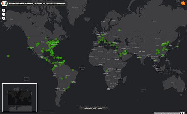
The image above is an interactive map that features over 250 of the hometown maps produced by architecture students for over 20 years. Click anywhere on the image to navigate "Where in the World Do Architects Come From", or visit http://scholar.library.miami.edu/hometownmaps/
The images can also be viewed through the UM LIbraries Digital Collections portal in the School of Architecture Digital Collection.
Suggested Subject Headings (keyword searches)
Fairly comprehensive gazetteer of world place names and features excluding the USA.
Geonames
United States Geological Survey Geographic Names Information System
Gazetteer of United States place names and features.
GNIS
Columbia Gazetteer*:
World gazetteer with descriptions of places in addition to coordinates.
Columbia Gazetteer of the World
*Gazetteer:
Digital Sanborn Maps, 1867-1970 provides academic and public libraries digital access to more than 660,000 large-scale maps of more than 12,000 American towns and cities.
Social Explorer
Social Explorer provides quick and easy access to current and historical census data and demographic information. The easy-to-use web interface lets users create maps and reports to illustrate, analyze, and understand demography and social change. In addition to its comprehensive data resources, Social Explorer offers features and tools to meet the needs of demography experts and novices alike.
The Society of Environmental Journalists is the only North-American membership association of professional journalists dedicated to more and better coverage of environment-related issues. SEJ's mission is to strengthen the quality, reach and viability of journalism across all media to advance public understanding of environmental issues.
United Nations Environment Programme (UNEP)
The United Nations Environment Programme (UNEP) is the leading global authority on the environment. UNEP’s work is focused on helping countries transition to low-carbon and resource-efficient economies, strengthening environmental governance and law, safeguarding ecosystems, and providing evidence-based data to inform policy decisions.
U.S. Geological Survey (USGS)
The USGS is a science organization that provides impartial information on the health of our ecosystems and environment, the natural hazards that threaten us, the natural resources we rely on, the impacts of climate and land-use change, and the core science systems that help us provide timely, relevant, and useable information.